Last week, I returned the BCPL archive, where I was previously a research assistant, to get my hands on some of the favorites of their collection. The agency is moving to a new location early next year, but for now, a typical shelf is shown below.

I made the mistake of wearing a light colored shirt: by the end of the day, it was covered with red rot. The agency has managed, at one point or another, more than ten million acres, and it did so without computers. As you might expect, the ledger books, with thin line after thin line of land parcels, are large enough to crush a small human being. They certainly did a number on my fingers. These massive volumes, about 6 inches thick and wrapped in cloth to help protect users from red rot, are housed horizontally on rollers.

The BCPL archive holds the field notebooks of the original survey of Wisconsin by the United States General Land Office (GLO). The surveyors criss-crossed the state, marking trees and rocks to divide the western territories of the United States into square-mile sections. The markers they placed were, and remain, the basis for all legal land descriptions. In Wisconsin, winter held a distinct advantage for this work -- the surveyors could haul their measuring chains straight across the lakes on the ice. Indeed, when the surveyors came upon Madison, they were able to walk straight across Lake Monona and Mendota. An example of the Madison survey, complete with the very common “Entered March” … “Left Marsh.”

The field notebook above is one of hundreds, each carried along across hundreds of miles of Wisconsin territory, and now kept safely in fireproof cabinets in the archive. The survey notebooks, digitized and online, are used for a variety purposes, including studying Wisconsin's original tree cover and helping decide legal conflicts between land owners.
The field notebooks and a sketch map of the territory surveyed were sent back to a Surveyor General’s office, where plat maps like this one were created:

Every so often, a piece of land would have to be resurveyed, as happened to Picnic Point on the UW campus in the 1880s. The half-century between the original survey and the resurvey had witnessed both the alteration of the lake shore and the arrival of settlers in the City of Madison. The surveyor in the 1880s took the opportunity to note that a formation in the area "is occasionally used as a picnic ground.”

One of the reasons the GLO surveys were so important was that government revenue at all levels was dependent on land, through the sale of public land or the taxation of private land. Indeed, BCPL was founded to manage the millions of acres of land given to Wisconsin by the federal government. As a state, we received between 5 and 6 million acres to support the construction of railroads, 3.2 million acres of swamp land to promote swamp drainage and education, and 1.7 million acres to support local K-12 schools and the University of Wisconsin. Including other smaller land grants, Wisconsin received about 10,000,000 acres from the federal government.
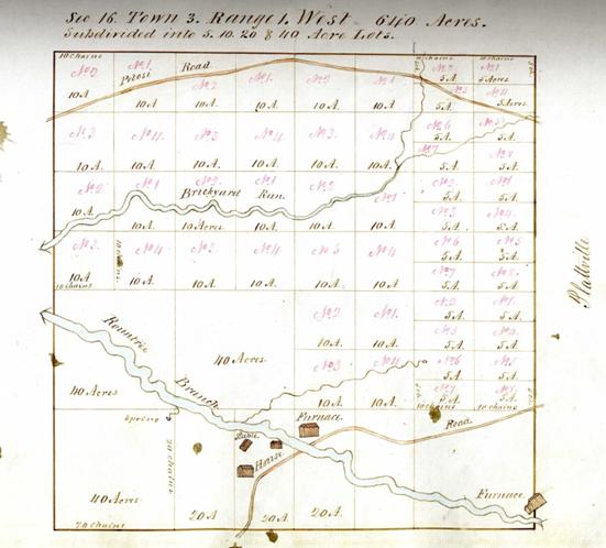
Many of the educational lands were individually appraised before being put on the public market. These appraisals can show a snapshot of the economic activity in the area. Here, we have a map of a square-mile section in Grant County, a county with rich mineral deposits. The appraisal map shows a house, a stable and two furnaces situated at the intersection of a river and a local road, as well as, of course, a number of ink splotches. This section is now home to the UW Platteville campus, and Pioneer Stadium sits just north of where the bottom right furnace once was.
The educational lands were sold to the public, and buyers typically were given some kind of payment plan. At a time when banks were scarce and unwelcome, the state was often the only source of a mortgage. The records of these sales sometimes bring out interesting characters. There are lands held by women and rights to land that were transferred more than ten times between different members of the community before being paid off. When the owner managed to pay the balance on the land, he or she would receive a patent from the state, shown below.

There was little restriction on how the money that came in from educational lands was to be spent, and in the early years many financial policies failed miserably. With few banks to provide loans, the state decided that the balance of the educational fund could be used to provide loans to any Wisconsin citizen who was willing to put up their land as collateral. In theory, this policy would have helped Wisconsinites while the fund received 7% interest on its loans (a very reasonable rate in the early days of statehood). Although it was a useful service for early settlers, this loan program failed when settlers began defaulting and the mortgaged lands they forfeited sold poorly on the market. In response, the loan program began loaning money only to school districts and municipalities. Below, a school district in Taylor County, a sparsely populated area at the time, applied and received a loan for $250 in 1877. Part of the fun of working with these records is determining what they mean – was this loan interest free, or have we simply not yet found the second document that deals with the interest payments?

And here, a loan of $48,000 was approved in 1953 to help a school district serving Marquette and Oconto Counties build an “addition of classrooms to the present Coleman High School.”

This program continues to this day. The interest provided by these loans allows BCPL to distribute more than $30 million a year to local school libraries.
[Post created by Amy Unger.]
No comments:
Post a Comment